earth_radius documentation
earth_radius gives the radius of the Earth.
Back to Climate Data Tools Contents.
Contents
Syntax
r = earth_radius
r = earth_radius(lat)
r = earth_radius(...,'km')
Description
r = earth_radius returns 6371000, the nominal radius of the Earth in meters.
r = earth_radius(lat) gives the radius of the Earth as a function of latitude.
r = earth_radius(...,'km') returns values in kilometers.
Example 1: Nominal radius
Get the nominal Earth radius in meters:
earth_radius
ans =
     6371000
...or in kilometers:
earth_radius('km')
ans =
        6371
Example 2: Latitude dependence of Earth's radius
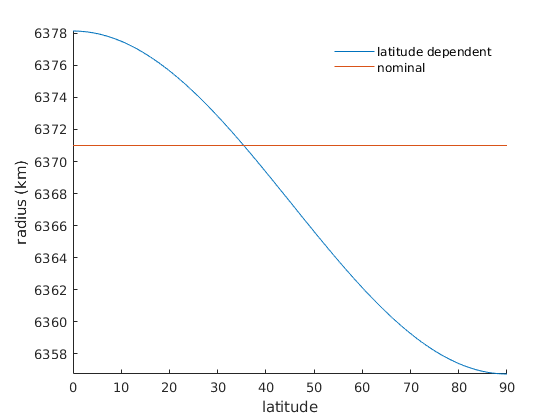
The Earth is more of an ellipsoid than a sphere, meaning its radius depends on latitude. Percentage-wise, how far off is the nomonal Earth radius at the Equator?
100*(earth_radius-earth_radius(0))/earth_radius(0)
ans =
   -0.1119
That says the nominal Earth radius of 6371 km is about a tenth of a percent smaller than the true radius at the Equator. Should we expect the same error at the North Pole?
100*(earth_radius-earth_radius(90))/earth_radius(90)
ans =
    0.2241
In fact, the nominal radius is about two tenths of a percent larger than the true radius at the poles. Here's Earth's radius as a function of latitude:
lat = 0:90;
r = earth_radius(lat,'km');

plot(lat,r)
axis tight
box off

hline(earth_radius('km')) % the nominal earth radius
xlabel latitude
ylabel 'radius (km)'

legend('latitude dependent','nominal')
legend boxoff
Example 3: A grid
Use cdtgrid to make a global grid, and earth_radius to get Earth's radius at each point on the grid:
[lat,lon] = cdtgrid;
r = earth_radius(lat,'km');
Plot them on a globe with globepcolor:
figure
globepcolor(lat,lon,r)
globeborders   % plots political boundaries
globegraticule % plots grid lines
axis tight     % removes empty space
cb = colorbar;
ylabel(cb,'radius (km)')

Author Info
This function and supporting documentation were written by Natalie S. Wolfenbarger and Chad A. Greene for the Climate Data Toolbox for Matlab, 2019.