dist2coast documentation
dist2coast determines the distance from any geolocation to the nearest coastline.
See also: island and topo_interp.
Back to Climate Data Tools Contents.
Contents
Syntax
di = dist2coast(lati,loni)
Description
di = dist2coast(lati,loni) gives the great-circle distance di in kilometers from the geolocation(s) lati,loni to the nearest coast line. For points on land, di is the distance to the nearest ocean. For oceanic locations, di is the distance to the nearest land.
Example 1: Global grid
For a quick example, use cdtgrid to create a quarter-degree global grid of Lat,Lon points, and determine how far each point is from the nearest coast line:
% Quarter degree grid:
[Lat,Lon] = cdtgrid(0.25);

% Distances to nearest coastline:
D = dist2coast(Lat,Lon);
Plot the distances to the nearest coast using imagescn:
imagescn(Lon,Lat,D)
cb = colorbar('location','southoutside');
xlabel(cb,'distance to nearest coastline (km)')

The first thing you might notice in the figure above is that some place in the Pacific appears to be more than 5000 km from the nearest land. That's actually false. (See the Limitations section below for more details on that.)
The second thing you'll notice is that distances from the coast are positive everywhere, whether on land or in the sea. If you'd like you can use the island function to dermine which cells are land versus which are ocean, and then set the land cells to negative values, like this:
land = island(Lat,Lon);

% Make land distances negative:
D(land) = -D(land);

figure
imagescn(Lon,Lat,D)
cb = colorbar('location','southoutside');
xlabel(cb,'distance to nearest coastline (km)')
cmocean('diff','pivot')
borders

Above we set the colormap to cmocean tarn (Thyng et al., 2016) and made it "pivot" about the zero value. Also added political boundaries with the borders function.
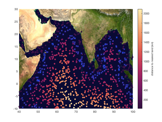
Example 2: Oceanic floats
Example 1 looked at a global grid, but now let's consider the case of scattered data. For example, Argo floats in the northern Indian Ocean. Here are some random data points that could be such Argo floats:
% 1500 random points around the Indian Ocean:
lat = 40*rand(1500,1)-10;
lon = 60*rand(1500,1)+40;

% Limit this random dataset to ocean points:
land = island(lat,lon);
lat(land) = [];
lon(land) = [];

% Plot the random datapoints:
figure
plot(lon,lat,'.','color',rgb('gray'))
hold on
he = earthimage;     % adds an earth image
uistack(he,'bottom') % places earth image below dots

Find out how far each float is from land and plot the distaces as scattered datapoints:
d = dist2coast(lat,lon);

scatter(lon,lat,30,d,'filled')

cb = colorbar;
ylabel(cb,'distance to nearest land (km)')

cmocean -matter % sets the colormap

Masking based on distance to land
Suppose you're only interested in data that's between 200 and 500 km from the coast. Get the indices corresponding to those points and use rgb to plot them as electric blue x marks:
ind = d>200 & d<500;

plot(lon(ind),lat(ind),'x','color',rgb('electric blue'))
Contouring
To make contour lines of distances from the coast, use meshgrid or cdtgrid to make a grid, get the distances of each grid point to the nearest coastline, and use island to mask out the land grid cells:
% Make a grid:
[Lon,Lat] = meshgrid(40:0.1:100,-10:0.1:30);

% Get distances from grid points to coast:
D = dist2coast(Lat,Lon);

% Mask out land:
D(island(Lat,Lon)) = NaN;

% Contour and label the contours:
[C,h] = contour(Lon,Lat,D);
clabel(C,h,'color','w')

Limitations
In Example 1, one of the first things we see is some place in the Pacific that appears to be more than 5000 km from land. In reality, the farthest point from land is Point Nemo, at (37.58S,139.39W) and a mere 2688 km from the nearest land. The reason dist2coast is so far off on this, is because dist2coast uses the same 1/8 degree mask as the island function to determine the presence of land. Any land that is not large enough to be present in the 1/8 degree dataset is not represented by island or dist2coast. Accordingly, this function is probably best suited for mesoscale processes that aren't affected by little islands.
Also noteworthy: the dist2coast function considers the Great Lakes of North America and other large bodies of freshwater to be not land, but water. As a result, the farthest distance from water in North America is in Wyoming, rather than somewhere in Canada where there are lots of big lakes.
Author Info
This function is part of the Climate Data Toolbox for Matlab. The function and supporting documentation were written by Chad A. Greene of the University of Texas at Austin.